Cafe nearby Papyros Cafe
Coronavirus disease (COVID-19) Situation
confirmed cases
6101379
deaths
37869
Greece
Cafe nearby Papyros Cafe
Papyros Cafe
25, Ravine, 115 21, Athina, GR Greece
contacts phone
:
+30
Latitude:
37.9787044
, Longitude:
23.7513827
larger map & directions
read more
nearest Cafe
188 m
parko.ATH
Athens
Cafe
read more
212 m
Tapas Bar
Greece, Κωνσταντινου Βεντήρη 7, Athina
Cafe
read more
339 m
Starbucks
Michalakopoulou 27, Athina
Cafe
read more
500 m
Gush
Ionos Dragoumi 58, Athina
Cafe
read more
588 m
Outopia Caffe Ltd
Antinoros 31, Athina
Cafe
read more
1.103 km
Ymmitou 67 pagkrati
Artotinis 2, Athina
Cafe
read more
1.139 km
Just Allegro
Imittou 76, Athina
Cafe
read more
1.225 km
CAPRICE CAFE - QUINTA AE
Imittou 101-103, ΑΘΗΝΑ - ΠΑΓΚΡΑΤΙ
Cafe
read more
1.239 km
Coffee Island
Eftichidou 47, Athina
Cafe
read more
1.249 km
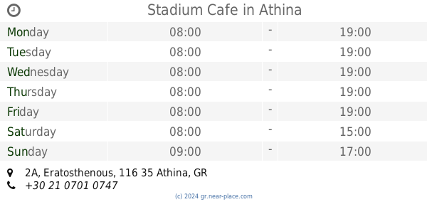
Stadium Cafe
Eratosthenous 2Α, Athina
Cafe
read more
1.551 km
Pschōchps
Solonos 81, Athina
Cafe
read more
1.568 km
Byssinókēpos
Zoodochou Pigis 27, Athina
Cafe
read more
1.625 km
Coffee Lab Akadimias
Akadimias 62, Athina
Cafe
read more
1.653 km
SUPERFLY CAFE
Empedokleous 28, Athina
Cafe
read more
1.657 km
Grēgórēs
Ippokratous 3-5, Athina
Cafe
read more
1.667 km
Centro Cucina E Caffe
Voulis 17, Athina
Cafe
read more
1.817 km
Polis Art Cafe
Athens
Cafe
read more
1.824 km
EM22
22, Emmanouil Benaki, Athina
Cafe
read more
1.84 km
Σερσέ Λα Φαμ
Mitropoleos 44, Athina
Cafe
read more
1.888 km
Santaroza3
Santaroza 3, Athina
Cafe
read more
1.914 km
Ermitaz
Omonoia 56, Athina
Cafe
read more
1.923 km
Commerse 1894
105 63, Evaggelistrias 3, Athina
Cafe
read more
1.968 km
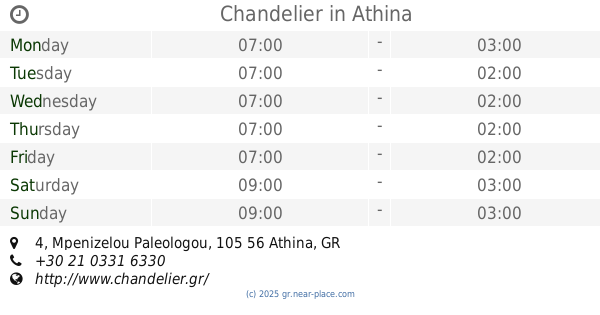
Chandelier
Mpenizelou Paleologou 4, Athina
Cafe
read more
2.063 km
Coffee Berry Omonoia
Platia Omonias 12, Athina
Cafe
read more
2.261 km
CAFE WORLD
Leoforos Andrea Siggrou 26, Athina
Cafe
read more
📑
all categories
Accounting
Administrative area level 1
Administrative area level 2
Airport
Amusement park
Aquarium
Art gallery
Atm
Bakery
Bank
Bar
Beauty salon
Bicycle store
Book store
Bowling alley
Bus station
Cafe
Campground
Car dealer
Car rental
Car repair
Car wash
Casino
Cemetery
Church
City hall
Clothing store
Convenience store
Country
Courthouse
Dentist
Department store
Doctor
Electrician
Electronics store
Embassy
Establishment
Finance
Fire station
Florist
Food
Funeral home
Furniture store
Gas station
General contractor
Grocery or supermarket
Gym
Hair care
Hardware store
Health
Hindu Temple
Home goods store
Hospital
Insurance agency
Jewelry store
Laundry
Lawyer
Library
Light rail station
Liquor store
Local government office
Locality
Locksmith
Lodging
Meal delivery
Meal takeaway
Mosque
Movie rental
Movie theater
Moving company
Museum
Natural feature
Neighborhood
Night club
Painter
Park
Parking
Pet store
Pharmacy
Physiotherapist
Place of worship
Plumber
Point of interest
Police
Post office
Premise
Real estate agency
Restaurant
Roofing contractor
Route
Rv park, camping
School
Shoe store
Shopping mall
Spa
Stadium
Storage
Store
Subpremise
Subway station
Supermarket
Synagogue
Taxi stand
Train station
Transit station
Travel agency
University
Veterinary care
Zoo
administrative area level 3
administrative area level 4
↑