Cafe nearby Zoya
Coronavirus disease (COVID-19) Situation
confirmed cases
6101379
deaths
37869
Greece
Cafe nearby Zoya
Zoya
43, Antonopoulou, 382 21, Volos, GR Grækenland
contacts phone
:
+30 2421 030424
Latitude:
39.3612025
, Longitude:
22.946736
larger map & directions
read more
nearest Cafe
26 m
προξενειο
Antonopoulou 37, Volos
Cafe
read more
60 m
Gregory's
Dimitriados 141-143, Volos
Cafe
read more
80 m
Mikel
Dimitriados 92, Volos
Cafe
read more
82 m
De-Τox Cafe
Δημητριάδος και Κ.Καρτάλη, Volos
Cafe
read more
107 m
Bruno Coffee Stores
Dimitriados 166, Volos
Cafe
read more
299 m
ELEFANTAS
T., Taki Ikonomaki 70, Volos
Cafe
read more
315 m
Kimōlía
Iasonos 13, Volos
Cafe
read more
320 m
Cruzar Cafe Volos
Koumoundourou 32, Volos
Cafe
read more
392 m
Pleasures Seaside Cafe + more
Argonafton 58, Volos
Cafe
read more
408 m
Da Vinc Cafe 2
Volos
Cafe
read more
408 m
Καφέ EPAYLIS
Volos
Cafe
read more
538 m
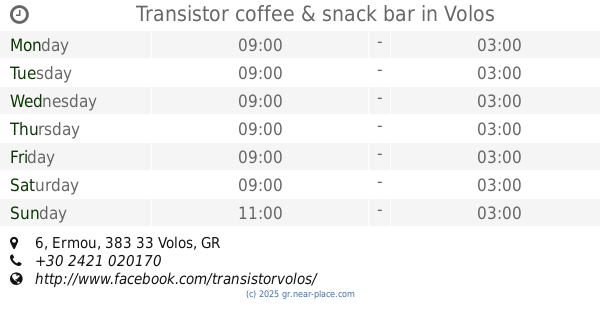
Transistor coffee & snack bar
Ermou 6, Volos
Cafe
read more
634 m
Σωματείο Λιμενεργατών Βόλου
Grigoriou Lampraki 1, Volos
Cafe
read more
641 m
Gameville
Polymeri 6, Volos
Cafe
read more
694 m
Da Luz
Deligiorgi 4, Volos
Cafe
read more
1.159 km
Ostria Cafe
Plastira 4, Volos
Cafe
read more
1.231 km
Specchio Coffee & Mοre
Πολυμερη 115Α, Polymeri 115, Volos
Cafe
read more
1.45 km
Isalos
17b, Plastira, Volos
Cafe
read more
1.688 km
Mikel
Polymeri 175, Volos
Cafe
read more
5.558 km
KRITSA Restaurant
CENTRAL SQUARE, PORTARIA PELION
Cafe
read more
5.671 km
Meli Coffee & more
Eparchiaki Odos Portarias-Makrinitsas 16, Volos
Cafe
read more
5.745 km
Archontika Karamarlis Boutique Hotel & Guesthouse
Makrinitsa
Cafe
read more
54.719 km
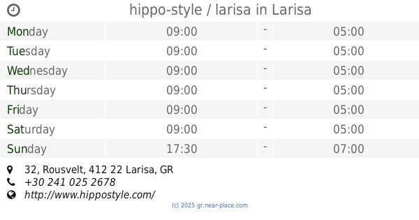
hippo-style / larisa
Rousvelt 32, Larisa
Cafe
read more
54.737 km
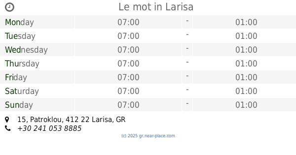
Le mot
Patroklou 15, Larisa
Cafe
read more
54.858 km
Floyd
Defkalionos 16, Larisa
Cafe
read more
📑
all categories
Accounting
Administrative area level 1
Administrative area level 2
Airport
Amusement park
Aquarium
Art gallery
Atm
Bakery
Bank
Bar
Beauty salon
Bicycle store
Book store
Bowling alley
Bus station
Cafe
Campground
Car dealer
Car rental
Car repair
Car wash
Casino
Cemetery
Church
City hall
Clothing store
Convenience store
Country
Courthouse
Dentist
Department store
Doctor
Electrician
Electronics store
Embassy
Establishment
Finance
Fire station
Florist
Food
Funeral home
Furniture store
Gas station
General contractor
Grocery or supermarket
Gym
Hair care
Hardware store
Health
Hindu Temple
Home goods store
Hospital
Insurance agency
Jewelry store
Laundry
Lawyer
Library
Light rail station
Liquor store
Local government office
Locality
Locksmith
Lodging
Meal delivery
Meal takeaway
Mosque
Movie rental
Movie theater
Moving company
Museum
Natural feature
Neighborhood
Night club
Painter
Park
Parking
Pet store
Pharmacy
Physiotherapist
Place of worship
Plumber
Point of interest
Police
Post office
Premise
Real estate agency
Restaurant
Roofing contractor
Route
Rv park, camping
School
Shoe store
Shopping mall
Spa
Stadium
Storage
Store
Subpremise
Subway station
Supermarket
Synagogue
Taxi stand
Train station
Transit station
Travel agency
University
Veterinary care
Zoo
administrative area level 3
administrative area level 4
↑