Restaurant nearby ToEat
Greece
Restaurant nearby ToEat
ToEat
25, Rousvelt, 412 22, Larisa, GR Greece
contacts phone
:
+30
Latitude:
39.6391134
, Longitude:
22.419727
larger map & directions
read more
nearest Restaurant
52 m
Papaioannou John
Larissas - Kozanis Rd (2nd km), Larissa, 41001
Restaurant
read more
68 m
Phagadḗmos
Νικηταρά 2 &, 23is Oktovriou, Larisa
Restaurant
read more
87 m
ΝΕΟΝ ΚΕΝΤΡΟΝ - Ντόκος
Larissa
Restaurant
read more
132 m
Group Mallioras S.A.
Greece
Restaurant
read more
138 m
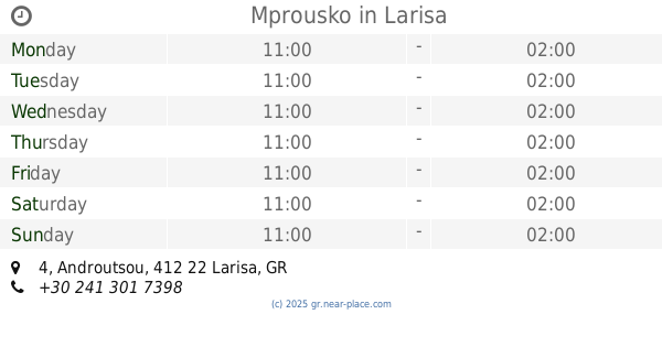
Mprousko
Androutsou 4, Larisa
Restaurant
read more
201 m
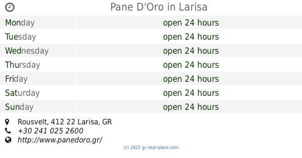
Pane D'Oro
Rousvelt, Larisa
Restaurant
read more
255 m
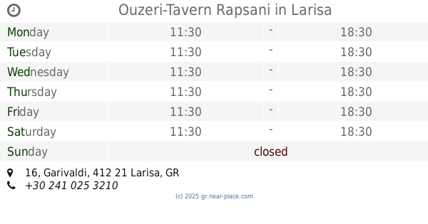
Ouzeri-Tavern Rapsani
18, Garivaldi 16, Larisa
Restaurant
read more
275 m
Ernos Ltd
Panagouli, Larisa
Restaurant
read more
284 m
PIATELAS
Vironos 7-11, Larisa
Restaurant
read more
289 m
to eat
Papaflessa 13-17, Larisa
Restaurant
read more
289 m
To Paradosiako
Filellinon 28-30, Larisa
Restaurant
read more
289 m
To Paradosiako
Φιλελλήνων 28-30, Larisa
Restaurant
read more
290 m
Παραδοσιακο ( ΦΡΟΥΡΙΟ )
Filellinon 28-30, Larisa
Restaurant
read more
291 m
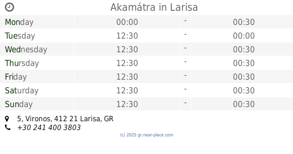
Akamátra
Vironos 5, Larisa
Restaurant
read more
296 m
Mpakalógatos
48, Filellinon 36, Larisa
Restaurant
read more
317 m
Philelloinōn
69, Filellinon 53, Larisa
Restaurant
read more
336 m
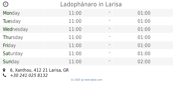
Ladophánaro
Xanthou 6, Larisa
Restaurant
read more
345 m
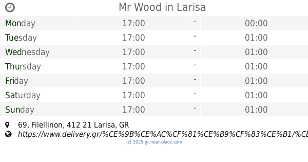
Mr Wood
Filellinon 69, Larisa
Restaurant
read more
401 m
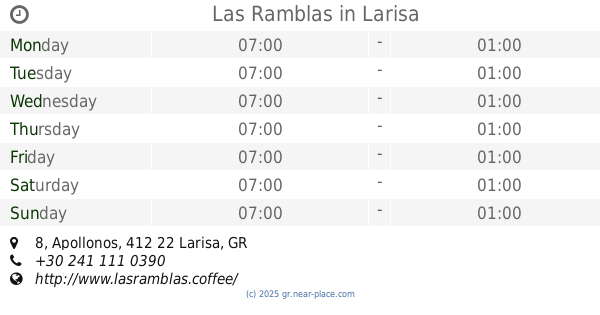
Las Ramblas
Apollonos 8, Larisa
Restaurant
read more
404 m
Το μαγειριό της γιαγιάς
Apollonos 9, Larisa
Restaurant
read more
405 m
Siontas, E., & Co. E.E.
Apollonos 5, Larisa
Restaurant
read more
406 m
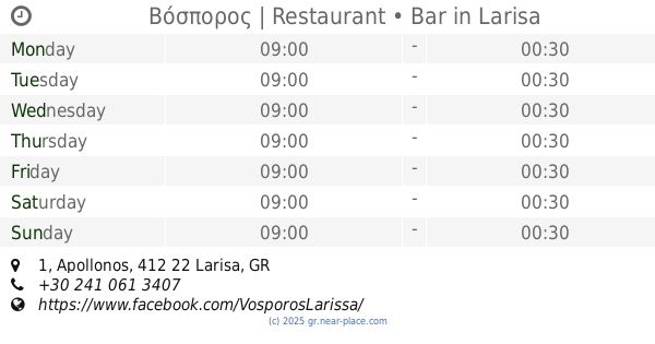
Βόσπορος | Restaurant • Bar
Apollonos 1, Larisa
Restaurant
read more
418 m
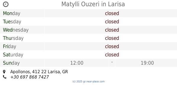
Matylli Ouzeri
Apollonos, Larisa
Restaurant
read more
426 m
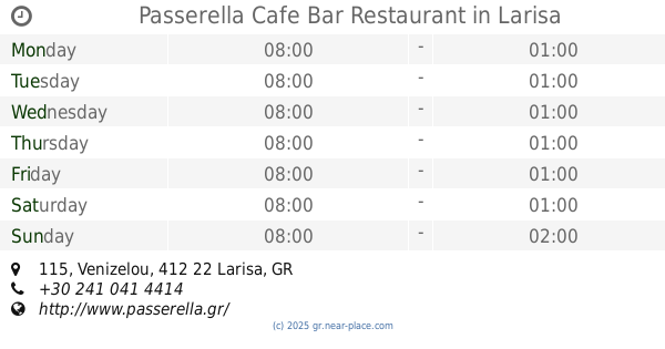
Passerella Cafe Bar Restaurant
Venizelou 115, Larisa
Restaurant
read more
1.811 km
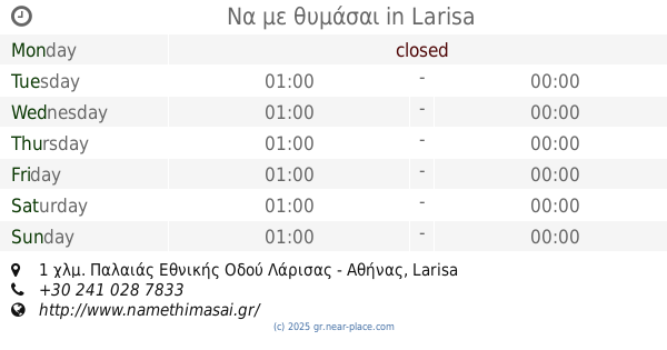
Να με θυμάσαι
1 χλμ. Παλαιάς Εθνικής Οδού Λάρισας - Αθήνας, Larisa
Restaurant
read more
📑
all categories
Accounting
Administrative area level 1
Administrative area level 2
Airport
Amusement park
Aquarium
Art gallery
Atm
Bakery
Bank
Bar
Beauty salon
Bicycle store
Book store
Bowling alley
Bus station
Cafe
Campground
Car dealer
Car rental
Car repair
Car wash
Casino
Cemetery
Church
City hall
Clothing store
Convenience store
Country
Courthouse
Dentist
Department store
Doctor
Electrician
Electronics store
Embassy
Establishment
Finance
Fire station
Florist
Food
Funeral home
Furniture store
Gas station
General contractor
Grocery or supermarket
Gym
Hair care
Hardware store
Health
Hindu Temple
Home goods store
Hospital
Insurance agency
Jewelry store
Laundry
Lawyer
Library
Light rail station
Liquor store
Local government office
Locality
Locksmith
Lodging
Meal delivery
Meal takeaway
Mosque
Movie rental
Movie theater
Moving company
Museum
Natural feature
Neighborhood
Night club
Painter
Park
Parking
Pet store
Pharmacy
Physiotherapist
Place of worship
Plumber
Point of interest
Police
Post office
Premise
Real estate agency
Restaurant
Roofing contractor
Route
Rv park, camping
School
Shoe store
Shopping mall
Spa
Stadium
Storage
Store
Subpremise
Subway station
Supermarket
Synagogue
Taxi stand
Train station
Transit station
Travel agency
University
Veterinary care
Zoo
administrative area level 3
administrative area level 4
↑