Restaurant nearby Pizza Fan
Greece
Restaurant nearby Pizza Fan
Pizza Fan
67, Vasili Tsitsani, 421 00, Trikala, GR Greece
contacts phone
:
+30 2431 039463
website:
www.pizzafan.gr
Latitude:
39.5543199
, Longitude:
21.7747378
larger map & directions
read more
nearest Restaurant
531 m
Pizza Papazacharias
Vasili Tsitsani 5, Trikala
Restaurant
read more
598 m
Trikala - Karditsa Restaurants S.A.
Apollonos 1, Trikala
Restaurant
read more
607 m
Steakhouse Nestor
Trikala
Restaurant
read more
607 m
ArsVivedi
4ο χλμ. Τρικάλων Λάρισας, 421, 00, Trikala
Restaurant
read more
638 m
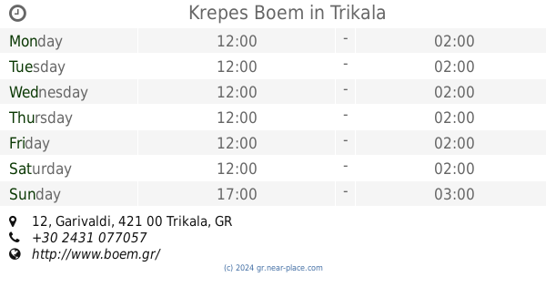
Krepes Boem
Garivaldi 12, Trikala
Restaurant
read more
658 m
Μπερδεμα Bar.Restaurant
Zografou 1, Trikala
Restaurant
read more
673 m
Μεζεδοπωλείο ο Ντρομάκας
Kapodistriou 15, Trikala
Restaurant
read more
685 m
Solo Pizza
5, Stournara, Trikala
Restaurant
read more
689 m
Κρεπερι Μποεμ
Garivaldi 6, Trikala
Restaurant
read more
698 m
Petit Dejeuner
Karanasiou 4, Trikala
Restaurant
read more
710 m
Live in Kitchen
Stournara, Trikala
Restaurant
read more
723 m
Mam
Asklipiou 42, Trikala
Restaurant
read more
726 m
O Χονδρός
Kapodistriou 14, Trikala
Restaurant
read more
735 m
MEATING
Kapodistriou 14, Trikala
Restaurant
read more
736 m
JIMMY'S & SONS
Asklipiou 24, Trikala
Restaurant
read more
1.512 km
Aēdónia
Rizariou 10, Trikala
Restaurant
read more
1.581 km
Dinopoulos Alexandros
Kalampakas 11, Trikala
Restaurant
read more
3.432 km
Kyratsoula
Georgiou Seferi 6
Restaurant
read more
5.078 km
Ο ΚΟΣΜΑΣ
6 χλμ Τρικάλων - Καρδίτσης, Agia Kiriaki
Restaurant
read more
6.411 km
Pizza Station Gyros Grepa
Megala Kalyvia
Restaurant
read more
8.59 km
MALLIORAS TRADITIONAL TAVERN
Agnantero
Restaurant
read more
8.782 km
TAVERN KAKARGIAS
Eparchiaki Odos Megalochoriou-Glinou 56, Glinos
Restaurant
read more
9.924 km
Fast Food-Creperie Dodos
Agnantero
Restaurant
read more
24.621 km
Estía
Iezekiil, Karditsa
Restaurant
read more
24.704 km
Philýra
Chatzimitrou 9, Karditsa
Restaurant
read more
📑
all categories
Accounting
Administrative area level 1
Administrative area level 2
Airport
Amusement park
Aquarium
Art gallery
Atm
Bakery
Bank
Bar
Beauty salon
Bicycle store
Book store
Bowling alley
Bus station
Cafe
Campground
Car dealer
Car rental
Car repair
Car wash
Casino
Cemetery
Church
City hall
Clothing store
Convenience store
Country
Courthouse
Dentist
Department store
Doctor
Electrician
Electronics store
Embassy
Establishment
Finance
Fire station
Florist
Food
Funeral home
Furniture store
Gas station
General contractor
Grocery or supermarket
Gym
Hair care
Hardware store
Health
Hindu Temple
Home goods store
Hospital
Insurance agency
Jewelry store
Laundry
Lawyer
Library
Light rail station
Liquor store
Local government office
Locality
Locksmith
Lodging
Meal delivery
Meal takeaway
Mosque
Movie rental
Movie theater
Moving company
Museum
Natural feature
Neighborhood
Night club
Painter
Park
Parking
Pet store
Pharmacy
Physiotherapist
Place of worship
Plumber
Point of interest
Police
Post office
Premise
Real estate agency
Restaurant
Roofing contractor
Route
Rv park, camping
School
Shoe store
Shopping mall
Spa
Stadium
Storage
Store
Subpremise
Subway station
Supermarket
Synagogue
Taxi stand
Train station
Transit station
Travel agency
University
Veterinary care
Zoo
administrative area level 3
administrative area level 4
↑